Click to enter complete search
Why you design a city with data
8th July 2019

Designing our cities and towns based on the foundations of measurable and verified information seems like the obvious way things should be done - particularly when the impact of getting it wrong can affect the lives of millions of people.

It would surprise many though that this isn’t always the way that things are done. Instead large parts of cities or whole new neighbourhoods are designed on the whim and intuition of architects, urban designers and planners. Sometimes it has worked; but too often it has failed and the scars of poor city planning are felt across the UK and around the world.

A different approach began to emerge in the 1960s with the pioneering work of Jane Jacobs and her seminal book The Death and Life of Great American Cities, which advocated the observation of daily life and designing for people based on these observations.

Whilst this new observational approach of ‘people-oriented’ cities took a while to gain traction, it slowly built momentum through other advocates and inspired other urbanists such as Jan Gehl who became known in the 1970s and ‘80s for his meticulous recording of public spaces, spending hours watching how people moved through, lingered and used space.

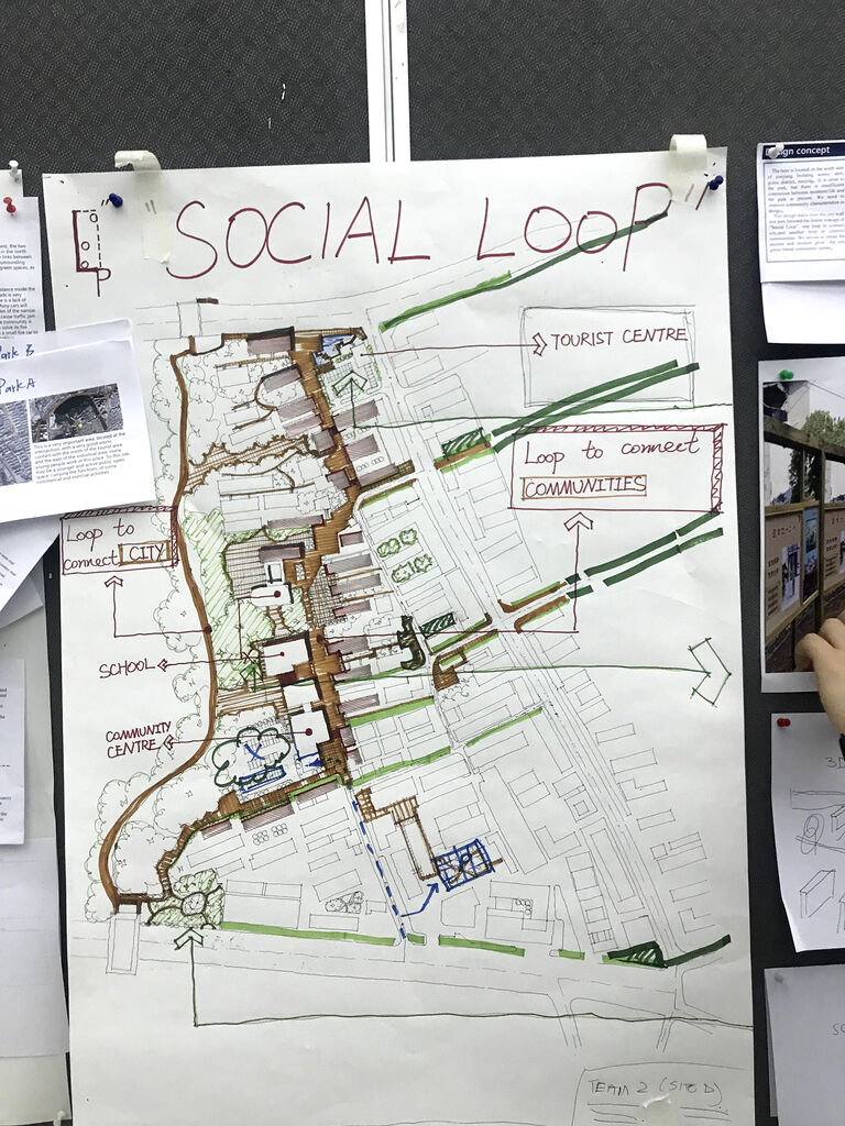
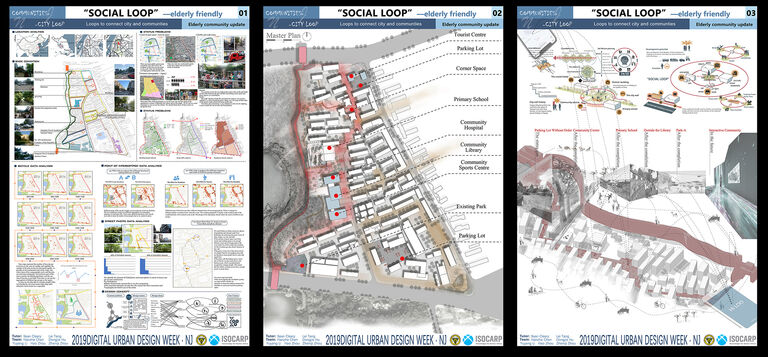
Move on another 30 years and things have changed drastically. We no longer need to physically sit in a space and collect information, instead our cities are collecting data for us at an unprecedented pace through embedded sensors, mobile phone data and the ominous ‘Internet of Things’. If all of this information was opened up to city planners and urban designers, would we understand the city better and be able to tailor design proposals differently to better serve the needs of the communities touched by the urban renewal process?

It is within this context that I was invited to participate at the International Design Week for Digital Urban Design by South East University Nanjing (SEU) and the International Society of City and Regional Planners (ISOCARP) in Nanjing, China.

The organisers of the event assembled four teams of architecture, landscape architecture and planning students from some of China’s top universities to participate. Each of the groups was supported by an international expert and a local expert as well as faculty staff from SEU.

The focus of the week was to use city data in the regeneration of an existing neighbourhood in the north-west of the city. The challenge was to use the data to not only understand the dynamics of the neighbourhood but to demonstrate how it influenced design decisions as well as considered the ongoing impact and integration of technology and data on the future evolution of the area.

The intense five-day programme involved site visits, tutorials, lectures and a final presentation to a panel of judges made up of senior Professors from SEU, experts in digital technologies from the University of Sheffield and Sebastien Goethals - the vice-president of ISOCARP.

Students were given a baseline set of city data which included information on existing land uses, buildings, points of interest, mobile phone and Mobike movement data but were also encouraged to source and explore other publically available data.

Some teams explored social media ‘chatter’ to understand how people felt about their neighbourhood and whether residents had an emotional attachment to place. Other groups used data mining techniques to extract thousands of streetview photos and used machine learning to analyse the images and assess the quality of the streetscape and the quantum and connection to greenspace, or used data models to simulate the movement of people after design interventions had been made.

All groups provided a unique spin on the workshop theme and successfully demonstrated the potential of ‘big data’ within the design process for urban design. Many great discussions happened through the week either in tutorials and crits or over dinner and drinks. Here are five main takeaways from the week:

Data should be used in a cyclical way

Data is useless in and of itself. It is not until you sort it, analyse and process it that it becomes useful and insightful. The teams found that without a strong initial design concept and idea the analysis of the information becomes slightly meaningless. It wasn’t until students began to form ideas about what was important in their projects that a more innovative approach to using data was uncovered.

Data is useful for informing the big idea but it still involves creativity and an emotional response to the site to form a strong concept. A cyclical approach of analysis, design, analysis, design was found to be the most successful so that teams could take advantage of the relative strengths of machines and humans.

Machines vs Humans

There are some things that machines can do very well and things that they can’t. Humans and machines can also have a different perspective on the same things. When the teams visited the site we tended to point our cameras at things that interested us or caught our eye and therefore took a more emotive but filtered perspective to the site.

With machines this isn’t the case, they are systematic and comprehensive and able to process vast amounts of information that humans can’t. No one-way is correct but there should a recognition that both have value.

Consider the future use of technology today

Some of the most interesting discussions were about how (or if) technology should be integrated into the urban environment and how it could have positive and negative impacts on the future communities. On one hand there is an argument that cities aren’t static and that masterplans should be flexible and have the ability to adapt over time. Technology could be used to measure and monitor activity on the site which could, for example, inform the programming or even physical attributes of different spaces within the design.

It was also felt that if technology was integrated within the design it could also be used to manage the urban environment and respond to different stimuli – for example, could sensors monitor flows of cars and people within the masterplan and use dynamic signage to direct cars away from people at busy times of the day?

Data is not accessible to or generated by everyone equally

There was a recognition that not all segments of society have equal access to technology and that this could be a disadvantage for them. The teams quickly found that not having data or finding gaps in the data could tell you something too – it often correlated with areas of older residents who did not use mobile phones as often as younger residents.

In a neighbourhood that had a large ageing population the discussion became focused on how can technology and access to data itself be made more accessible to older residents and how design decisions shouldn’t be prejudiced by data generated by a narrow segment of society.

Technology can be an effective tool for empowering communities

If all of the above can be managed and balanced carefully then the overall conclusion was that it could be a powerful tool for allowing communities to have a voice in how their neighbourhood is shaped both at the masterplan stage as well as moving forward. Rather than an isolating element, technology and data had the potential to unite, mobilise and empower residents for positive change.

Overall the workshop was a big success and a special thank you must go to the organisers of the week from ISOCARP and SEU but most of all to the students themselves who were talented, hard-working and a joy to work with and exchange ideas with. The work and outcomes from the week will be presented at the 55th ISOCARP World Planning Congress in Jakarta in September 2019.